Far from being a simple mixing of waters, the richness of the St. Lawrence Estuary is the result of a precision mechanic akin to clockwork. It is the unique underwater topography of the Laurentian Channel that, by forcing the upwelling of cold, nutrient-rich waters with every tide, orchestrates the massive concentration of krill. This phenomenon transforms a geographic area into an essential energy buffet, explaining why the largest animals on the planet, such as the blue whale, make a vital stop there rather than a simple visit.
The image of a blue whale, the largest animal to ever exist, feeding in the waters of a river, is profoundly striking. The St. Lawrence is not a river like any other; it is the stage for a colossal encounter between the fresh water of the Great Lakes and the salt water of the Atlantic. Many stop at this simple observation to explain its prodigious biodiversity. Terms like “pantry” or “mixing zone” are used—terms that are accurate but only skim the surface of the system’s complexity and beauty.
However, the true key to this abundance lies not in the mixing itself, but in the precision mechanics that orchestrate it. While the massive presence of whales, seals, and seabirds is the visible consequence, the primary cause is a fascinating interaction between underwater geology, tidal forces, and plankton behavior. Understanding this phenomenon means moving from the status of a simple spectator to that of an enlightened observer, capable of appreciating the natural engineering at work.
This article invites you to dive into the heart of this ecosystem. We will decipher how the invisible topography of the Laurentian Channel triggers a powerful upwelling phenomenon, how life adapts to this salinity gradient, and how the largest marine predators exploit this providential manna. You will also discover the practical and sometimes dangerous aspects of this environment, from harvesting seaweed to the caution required in the face of the tides.
To guide you through the different facets of this natural spectacle, this article is structured to take you from the general phenomenon to the specific adaptations that result from it. Here is the plan for our exploration.
Summary: The Hidden Mechanics of the St. Lawrence Estuarine Ecosystem
- What is the upwelling phenomenon and why does it attract blue whales?
- How to discover starfish and sea urchins during the equinox spring tides?
- Middle or Maritime Estuary: where does biodiversity change radically?
- The mistake of getting surrounded by the rising tide on the mudflats
- Kombu or sea lettuce: which seaweeds can be legally harvested on the shoreline?
- Why do strong current zones attract so many marine predators?
- 4 tons of krill: why does the blue whale only come to the St. Lawrence to eat?
- How do seals and whales survive in 0°C water without freezing?
What is the upwelling phenomenon and why does it attract blue whales?
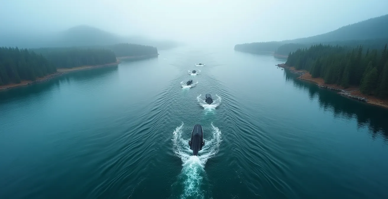
The upwelling phenomenon, or the rising of water, is the true engine of the estuarine pantry. It is an oceanographic process where deep, cold, and nutrient-laden waters are pushed toward the surface. In the St. Lawrence Estuary, this mechanism reaches a remarkable intensity at a specific location: the head of the Laurentian Channel, near Tadoussac. At this point, the seabed rises abruptly from 300 to only 20 meters deep, creating a veritable underwater barrier. Twice a day, at high tide, the dense, salty layer of Atlantic water rushing into the channel hits this obstacle and is violently forced upward.
This upwelling has a dual effect. On one hand, it injects nutrient salts (nitrates, phosphates) into the surface, which act as fertilizer and trigger an explosion of planktonic life (phytoplankton). On the other hand, it traps and concentrates zooplankton, particularly krill, which feeds on this phytoplankton. The krill is then trapped in this “hydrodynamic dead-end,” creating aggregations of exceptional density. Studies have revealed the presence of exceptional quantities of up to 100,000 tons of krill detected during a single campaign in 1994.
For blue whales and other rorquals, which are baleen whales that feed by filtration, this concentration of food is an invaluable boon. They no longer need to travel vast oceanic expanses to find their food; the estuary serves it to them on a silver platter. It is this energy efficiency that attracts them in such large numbers every summer. As Canadian researchers point out, the estuary is the site of a unique phenomenon, as indicated by this analysis from the Revue des sciences de l’eau:
This region is the site of the richest aggregation of krill documented to date for the Northwest Atlantic.
– Researchers from UQAR and Fisheries and Oceans Canada, Revue des sciences de l’eau – Journal of Water Science
It is therefore this unique combination of a particular underwater topography and tidal force that initiates the entire food chain, making the Tadoussac region one of the best sites in the world for observing large marine mammals.
How to discover starfish and sea urchins during the equinox spring tides?
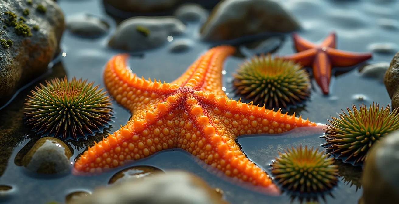
While whales are the stars of the estuary, the intertidal zone—the strip of land revealed and covered by the rhythm of the tides—is a fascinating universe in itself. It is an open-air laboratory that reveals a rich and colorful biodiversity, accessible on foot. The most favorable periods for this exploration are the spring tides, particularly those coinciding with the spring (March) and autumn (September) equinoxes, when the tidal range (the difference in height between high and low tide) is at its maximum, revealing areas that are rarely accessible.
By cautiously exploring the rocky mudflats and tide pools left by the receding tide, one can observe a multitude of organisms adapted to this life between two worlds. This is where you can easily find the common starfish (Asterias vulgaris), with its bright orange color, and the green sea urchin (Strongylocentrotus droebachiensis), which nestles in crevices. These creatures, along with crabs, anemones, and a variety of seaweed, create ephemeral mosaics of life.
However, observing this ecosystem requires respect and preparation. National parks like Bic or the intertidal zones of Gaspésie are prime locations for this activity, but it is crucial to follow best practices to avoid disturbing this fragile environment. Never turn over rocks without putting them back, do not move the animals, and, above all, keep an eye on the time.
Your Action Plan for Intertidal Exploration in Quebec
- Consult the tide tables from the Canadian Hydrographic Service to identify spring tide days around the equinoxes (March and September).
- Choose a recognized observation site such as Bic National Park or the coasts of Gaspésie and plan to arrive about an hour before low tide.
- Look for the common starfish (Asterias vulgaris) and the green sea urchin (Strongylocentrotus droebachiensis) in the pools of water trapped between the rocks.
- Adopt a respectful attitude: observe without touching, do not move animals, and do not flip over the rocks that serve as their shelter.
- Be vigilant and start heading back to dry land at least 30 minutes before the rising tide begins to ensure your safety.
Middle or Maritime Estuary: where does biodiversity change radically?
The St. Lawrence Estuary is not a homogeneous entity. Scientists divide it into three distinct sections based on the salinity gradient: the fluvial estuary (fresh water), the middle estuary (brackish water), and the maritime estuary (salt water). The transition between these zones is not gradual; it occurs at true ecological boundaries where the composition of fauna and flora changes radically. The most spectacular of these boundaries is located between the middle estuary and the maritime estuary.
The tipping point is located precisely at the head of the Laurentian Channel, around Tadoussac. This is where the water reaches full oceanic salinity, marking the beginning of the maritime estuary and the Gulf of St. Lawrence. This change in water chemistry acts as a filter, determining which species can live where. Some species, like capelin, can tolerate large variations in salinity, while others are extremely sensitive to it.
One of the best examples of this zonation is the St. Lawrence beluga. This population, resident year-round, is perfectly adapted to the conditions of the estuary, its primary habitat. Observations of belugas in the Gulf are very rare and sporadic. They act as a true indicator species, whose range outlines the contours of this invisible boundary between the middle and maritime estuaries. Their concentrated presence testifies to the existence of an ecosystem with unique characteristics, distinct from the adjacent Atlantic Ocean.
This division explains why biodiversity is not the same along the river. Moving up toward Quebec City, marine species such as large rorquals, grey seals, or cod become scarce, giving way to brackish and then freshwater species. The meeting of waters is thus not a simple mix, but a succession of environments with very specific living conditions, creating a mosaic of habitats over hundreds of kilometers.
The mistake of getting surrounded by the rising tide on the mudflats
Exploring the mudflats—those vast sandy or silty expanses revealed at low tide—is a popular activity on the shores of the St. Lawrence. However, the charm of these lunar landscapes hides a very real and often underestimated danger: the speed of the rising tide. The most common and dangerous mistake is venturing far onto the foreshore without monitoring the time and being caught off guard, or even surrounded, by the return of the sea.
The danger does not come so much from a sudden wave as from a gradual, silent, and relentless rise in water. On very flat terrain, the water does not just rise vertically; it advances horizontally over hundreds of meters. According to data from the Canadian Hydrographic Service, the tide can rise several centimeters per minute in some areas, meaning that passages that were dry moments earlier can become impassable channels in no time. A distracted walker can thus find themselves isolated on a sandbank, with water on all sides, well before the general level becomes threatening.
The configuration of the terrain is crucial. Tidal channels, even shallow ones, fill up first and can quickly cut off the retreat route to the mainland. Losing visual landmarks due to fog, which can lift very quickly on the river, adds an extra risk. Every year, the Canadian Coast Guard must intervene to rescue people trapped by the tide.
Prevention is therefore essential. Before any outing, it is imperative to consult the tide tables, note the time of low tide, and plan your return well before the water starts to rise. You must always keep landmarks on the coast and carry a means of communication to call for help in case of emergency (the number is *16 on a cell phone). The beauty of the mudflats is savored with caution and respect for the power of the river.
Kombu or sea lettuce: which seaweeds can be legally harvested on the shoreline?
The St. Lawrence foreshore is not just a place for observation; it is also a pantry for humans. The practice of harvesting edible seaweed, or coastal foraging, is gaining popularity. The Quebec coastline offers a beautiful diversity of tasty and nutritious seaweeds, but their harvesting is governed by regulations that are essential to know for sustainable and legal practice. Fisheries and Oceans Canada (DFO) regulates this activity.
The DFO primarily distinguishes between harvesting for personal use and commercial harvesting. For personal use, it is generally permitted to harvest a limited quantity (often up to 50 kg per day) without a permit. However, certain species or zones may be subject to specific restrictions. It is crucial to ensure that the harvesting area is healthy, far from ports, marinas, and river mouths that could carry pollutants. Seaweeds, like shellfish, can accumulate contaminants.
Among the most common and appreciated species are sea lettuce and dulse, which are easily harvested at low tide on rocks. Others, like sugar kelp (kombu), grow lower on the foreshore and sometimes require a permit. The following table, based on information from the Fisheries and Oceans Canada aquatic species index, summarizes the characteristics of the main edible seaweeds of the St. Lawrence:
| Species | Scientific Name | Harvesting Zone | Optimal Period | Legal Status (Personal Harvest) |
|---|---|---|---|---|
| Dulse | Palmaria palmata | Rocky intertidal zone | May-September | Authorized |
| Sugar Kelp (Kombu) | Saccharina latissima | Subtidal zone (lower foreshore) | June-August | Permit sometimes required |
| Sea Lettuce | Ulva lactuca | Intertidal zone | May-October | Authorized |
| Wild Nori (Purple Laver) | Porphyra sp. | Exposed rocks (upper foreshore) | April-June | Authorized |
Proper identification is key to safe harvesting. It is recommended to bring a good identification guide or participate in a guided outing to learn how to recognize species without error. Harvesting should always be done respectfully, by taking only part of the plant to allow it to regenerate.
Why do strong current zones attract so many marine predators?
An apparent paradox of the ocean is that the most turbulent areas, those where currents are strongest, are often the richest in life. Far from being aquatic deserts, sectors of strong currents, the edges of channels, and rocky points are veritable magnets for predators, from fish to marine mammals. The reason is simple: currents act as food conveyors and concentrators. For a predator, hunting in a current is like standing at the exit of a food highway.
In the St. Lawrence Estuary, this principle is magnified. Powerful tidal currents flowing along the steep slopes of the Laurentian Channel interact directly with the behavior of krill. These small crustaceans tend to perform daily vertical migrations. The currents disrupt this cycle and passively concentrate them in specific areas. They are literally trapped and accumulated in eddies and counter-currents, creating “patches” of food of extreme density.
This is why whales, seals, and large schools of fish are not distributed randomly. They are observed systematically patrolling along current lines, at the mouths of fjords like the Saguenay, or at the head of underwater channels. They have learned to recognize these areas where hunting effort is minimal for maximum energy gain. The current does the heavy lifting by delivering the food to them.
This phenomenon explains the spectacular concentration of marine mammals between Tadoussac and Les Escoumins. The krill, after being brought to the surface by upwelling, is then swept and trapped by tidal currents in the dead-end formed by the head of the channel. For a rorqual, this is an ideal situation: food is not only abundant but also predictable and concentrated, considerably reducing the energy spent on feeding.
Key Takeaways
- The abundance of life in the St. Lawrence is not due to simple mixing, but to a precise upwelling mechanism caused by underwater topography.
- This phenomenon massively concentrates krill, which is the dietary base of the food chain and the main reason for the presence of whales.
- The estuarine ecosystem is strongly zoned by salinity, creating ecological boundaries that determine species distribution.
4 tons of krill: why does the blue whale only come to the St. Lawrence to eat?
The summer presence of the blue whale in the St. Lawrence Estuary is neither a coincidence nor a vacation. It is a survival mission dictated by a colossal energy requirement. To maintain its body mass, which can exceed 100 tons, a blue whale must consume about 4 tons of krill per day. This staggering figure puts the vital importance of the estuarine pantry into perspective. The St. Lawrence is not a breeding or calving ground for blue whales; it is exclusively a feeding ground.
After spending the winter in the warmer waters of the tropics where food is scarce and where they mostly fast, whales migrate to higher latitudes to replenish their fat reserves. They must find areas where food is not only present but extraordinarily concentrated for feeding to be energetically profitable. Every mouthful must count. This is where the krill concentration mechanism in the estuary takes on its full meaning.
The Saguenay–St. Lawrence Marine Park represents an ecological exception, housing the highest density of krill in the entire Northwest Atlantic. For a blue whale, entering the estuary is like entering a restaurant where its favorite dish is served in abundance and at will. It can thus satisfy its daily needs of several tons of food with relative ease, allowing it to quickly rebuild the layer of blubber that will serve as an energy reserve for the next migration and breeding season.
This dependence on such a specific and localized food source makes these giants particularly vulnerable. Any disruption to this fragile balance, whether from climate change affecting plankton, pollution, or maritime traffic, can have direct consequences on their ability to survive. The blue whale does not come to the St. Lawrence by choice, but by imperious necessity.
How do seals and whales survive in 0°C water without freezing?
Observing a seal basking on ice or the breath of a beluga in the icy waters of winter raises a fundamental question: how do these warm-blooded animals survive in water whose temperature borders on the freezing point? Marine mammals of the St. Lawrence, many of which are year-round residents like the common seal and the beluga, have developed remarkable physiological and behavioral adaptations to combat heat loss.
The first line of defense is a thick layer of insulating fat located under the skin, known as “blubber”. This layer, which can reach several tens of centimeters thick in large whales, acts like a built-in wetsuit. It insulates vital organs from the outside cold and also serves as an energy reserve. In the St. Lawrence beluga, which lives as a resident population year-round in waters between 0 and 5°C, this layer of fat is essential for its winter survival.
In addition to this passive insulation, marine mammals possess a very sophisticated blood circulation system. A counter-current heat exchange mechanism allows warm blood going to the extremities (flippers, tail) to warm the cold blood returning from them, thus limiting heat loss. Their metabolism is also adapted to produce more internal heat. Finally, their massive body shape, with a low surface-to-volume ratio, minimizes the contact surface with cold water and therefore heat loss.
Behavior also plays a role. Seals leave the water to rest and warm up in the sun on rocks or ice, a strategy called “hauling-out.” The fact that the common seal, a permanent resident, gives birth to its pups between mid-May and mid-June in the estuary, when the waters are still very cold, testifies to the efficiency of these adaptations passed down from generation to generation. It is a true biological feat that allows them to thrive where most mammals would freeze in minutes.
Ultimately, the St. Lawrence Estuary is much more than a simple geographical meeting point. It is a living system, pulsing to the rhythm of the tides, whose complexity and ingenuity command admiration. Every visitor who has the chance to observe the wildlife there should now see, beyond the beauty of the spectacle, the underlying mechanics that make it possible. To continue enjoying this richness, the next step is to adopt an even more respectful and informed approach during your explorations.